


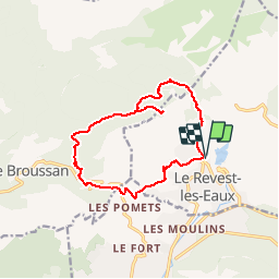
Tour du Mont Caume

soca
User

Length
14.5 km

Max alt
715 m

Uphill gradient
677 m
Km-Effort
24 km

Min alt
185 m

Downhill gradient
677 m
Boucle
Yes
Creation date :
2015-05-26 00:00:00.0
Updated on :
2015-05-26 00:00:00.0
5m
Difficulty : Medium

FREE GPS app for hiking
 SityTrail
IGN / Geographical institutes
SityTrail Plus
The world is yours!
About
Trail Walking of 14.5 km to be discovered at Provence-Alpes-Côte d'Azur, Var, Le Revest-les-Eaux. This trail is proposed by soca.
Description
Départ du Revest, col des morts,Aven Mt Caume,Bruguiére,col du corps de garde,les baumes,mal vallon, le Revest.
Positioning
Country:
France
Region :
Provence-Alpes-Côte d'Azur
Department/Province :
Var
Municipality :
Le Revest-les-Eaux
Location:
Unknown
Start:(Dec)
Start:(UTM)
737846 ; 4784606 (31T) N.
Comments